Tuesday, August 23, 2016
I thought I'd try a little video diary format this year in hopes of doing a better job of documenting the adventure. My notes never seem to make it out of a journal so maybe something this lazy is the solution. Here is my first attempt taken on Sunday at Salem Lake. Here I talk a little about my bike setup for the trip. My luggage came from a Winston-Salem shop called Rockgeist and I couldn't be happier with Greg's work.
Monday, August 22, 2016
Adventure 2016: San Juan Huts Durango to Moab
This year I'm giving the motorcycles a break (for their health) and giving my bicycle an adventure (for my health) along the San Juan Huts route from Durango, Co to Moab, Ut. The trip runs 7 days and 6 nights with travel by mountain bike and accomodations via backcountry huts. Maybe I'll come back to share stories from the trip. Maybe not. There is definitely a trend toward not. Facebook just makes it too easy these days. But the blog is great for sharing a map of my travel since I'll be out of cell phone range for days at a time. Remember, I have a 911 button with rescue services support if needed. So don't worry if I stop for awhile. This is a once-in-a-lifetime trip and I'll stop as often as necessary to soak it all in.
Routing should begin on Tuesday Sept. 30 and stop on Monday Sept. 5. Until then it's just an empty map.
Friday, July 18, 2014
Continental Divide Route Part 2: Denver to Glacier
We ran out of time on the Continental Divide Route in 2012 right at the Colorado-Wyoming state line. It was a great ride and a real adventure for me because it included a ride across the country bookending the CDR section. While this was a big thrill for me it was a re-run for everyone else. To spare everyone suffering through the plains again we decided to trailer the bikes out this time.
So the plan for 2014 is to rendezvous in Denver and head back to where we left off in 2012 to finish the CDR. Well, atleast the U.S. portion. For years we've ridden just close enough to Glacier to be disappointed our trip wouldn't allow a visit. So we made Glacier the destination this time. The route from Glacier back to Denver is completely unplanned but I think we all want to ride Beartooth Pass at the eastern gate of Yellowstone.
Maybe I'll be back with a summary and maybe I won't. I've been so bad at keeping that promise that I'm not even going to commit anymore. I will share my SPOT information via the map below though. Otherwise Facebook pages of the individual riders is probably the best bet.
Let me leave a special note for my mother here: If I stop moving it's to enjoy the view, take a nap, swim in a lake, have a meltdown, etc. Don't worry about me! I have a "911" button on my SPOT in case of an emergency and a group of friends that watch out for me.
If there is a problem with the map above or you'd simply like more of a view then please follow this link: link to the Spotwalla webpage.
Sunday, July 7, 2013
Day 1: Suches, Ga to Bristol, Va
We woke up in a cloud that had settled over Suches. I've experienced this in Suches before and known it was nothing to fear. But after a night of wind and rain of a magnitude that it was hard to tell the difference inside the cabin I didn't have high hopes. There was no real reluctance in the group as we all have wet weather gear and I'd already adjusted our route to avoid water crossings due to the heavy recent rainfall. We finished cleaning up the cabin from the party the night before, tried as best we could to help Dan get packed up, and through on the layers of gear.
We were on the bikes by 9am and all things considered it was a happy miracle. We picked our way over Wolfpen Gap which is a road we've all ridden literally hundreds of times but even still I pushed the front a couple times as the wet twisties with a fully loaded bike through my bearings off. By the time we reached Hwy 129 (like 10 miles as the crow flies) the rain stopped, the fog lifted, and I could see patches of blue in the cloudy skies. We stopped for fuel and pulled off all that rain gear we just put on. We wouldn't need the rain gear for the rest of the day despite how bad the skies looked and that was pretty amazing.
The recent rain had flooded parts of Asheville, NC which is a pretty good benchmark for that entire region. I've never seen Hiawasee Lake that high which might actually be welcome considering how down it's been in recent years. But sure enough we came up against an impassable creek within a mile of getting to the offroad section of our ride. That ruined the out-and-back to Buzzards Roost which I'd kind of hyped so I hoped the visit to Max Patch would make up for it.
We all started the GPS routes and they work! This was a huge relief for me as last year they didn't. I couldn't stop grinning for hours. Enjoying the scenery, concentrating on riding at times, and enjoy vacation time is so much easier when you don't have to concentrate on navigating. The way I set up the routes we're just turning when the GPS tells us to. There are quirks still but I think we're figuring those out.
All that said, my route somehow bypassed Max Patch so I'm 0-for-2 on my local attractions. The only upside is that traffic in the vacinity was way more active that I enjoy and I'm sure Max Patch was the reason. We exited the dirt onto some great twisty roads that were dry except for some random spots. I don't know how much of our trip will be in the dirt because I can't distinguish surface types on the mapping software. But if it were all paved twisties like this I won't complain a bit! As an added bonus every waterway is flowing white water which constantly amazes me.
The rest of the day was mostly paved and we took some liberties to cut off a pig trail tour of mobile homes that we somehow ended up on. We ended up rolling into Bristol, Va at a very reasonable time, met up with Justin Mills (who will be joining us for the rest of the trip), and had a big dinner. We started the day with Dan's homemade smoothies and sustained ourselves on snacks and Kate's cookies (which are awesome!) so we could make time. Even a marginal Outback experience was greeted with joy.
All things considered this has been a fantastic day. The weather cooperated, the GPS routes are woking, and there haven't been any surprises with our bikes or gear. Tomorrow we're going to push a long day and make it to my Uncle's cabin in Gettysburg, Pa.
Friday, July 5, 2013
Epic Trip 2013: Appalachian Trail-ish Ride
It's that time of year again!
Hopefully the map above will populate with our progress. If not please try this link to the Spotwalla webpage. As you can see below this self-populating map idea failed last year but the link works.
The plan is to ride as close as we can to the Appalachian Trail north from Suches,Ga to somewhere in Maine. This is as close as we can get to Springer Mountain to Mount Katahdin. I'll do my best to update the blog on the way but if I miss a day don't worry. I'll go analog and just take notes and update the blog later. I hope you all enjoy the ride.
Friday, May 25, 2012
Epic Dualsport 2012: Continental Divide Ride
It's that time of year again! A little earlier in years past, a little different group, a different adventure, but hopefully the same fun. The plan this year is to ride our bikes from the east coast to New Mexico where we'll pick up the Continental Divide Ride, using GPS maps graciously shared with the world by Big Dog Adventures, and then we'll ride back home. The map is shown below and should begin populating on May 25th as I head to our meeting point in North Georgia. From there we have a loose schedule and alot of time to play with until June 6th when I plan to arrive at home. Lots of miles and lots of adventure await....
I'm having trouble with the latest Blogspot interface today and I can't get the map to load to this post. Please follow the link below while I figure this out.
You can also just copy this link into your browser if using this page is too much of a hassle.
Thursday, August 18, 2011
Epic Dualsport 2011: Salt Lake City to Denver
It's that time of year again!
Our basic route and overnight stops are:
Aug 20 SLC to Ferron
Aug 21 Ferron to Moab
Aug 22 Moab (White Rim Trail)
Aug 23 Moab to Norwood
Aug 24 Norwood to Lake City
Aug 25 Lake City to Gunnison
Aug 26 Gunnison to Fairplay
Aug 27 Fairplay to DEN
We're trying something new this year that might be fun also. We realized over the last year that it's pretty handy to be able to track each other since we can't exactly communicate well when we're riding. This works great when you can get your smart phone to communicate and this happens more than you might guess out in the middle of nowhere. So Ryan created one page where we'll be combining our tracks which makes it really easy for us to access one map to find each other. I'm "JEM" on the map if you want to check it out. I predict it looks like 9 guys having a dizzy bat race.
Sunday, October 24, 2010
Pisgah Forest for leaf viewing
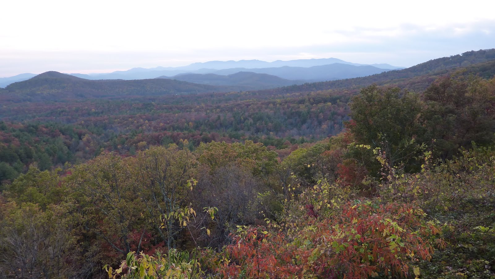
Dieter and I both had some hard weeks of work and weren't much fun to be around anymore. Our solution: Drop off the grid and enjoy nature! We kept the planning to a minimum but without a better idea we headed to the western edge of the closest version of Pisgah National Forest (it's disjointed if you look at a map). So we set our sights on Jonas Ridge which I remember fondly of the top of the Hwy 181 climb on Bridge to Bridge. As we climbed Hwy 181 and took in the sight of Brown Mountain I thought it might be prudent to actually find a campground. We got luck and ended up a Down By The River campground. Although it's primarily a RV park it was pretty deserted on Saturday and we got some choice spots down by the Linville River.


We arrived late in the afternoon, hastily setup our tents, and took off west on the Blue Ridge Parkway to try to catch the sunset. The sky had turned a little cloudy which muted the fall colors but it was still a really nice sunset.


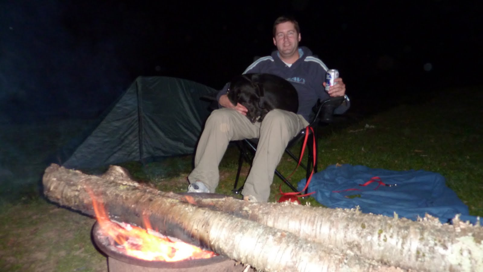
Night time came and the temp plunged. It was pretty cold but the fire kept us warm. Well that and Dieter's sporty black lapdog. I tried burning giant logs but Dieter came out ahead on that deal.

Sunday morning came and it was downright cold. I was snug in my overspec'ed sleeping bag but at some point you have to get up and that was chilly. I got breakfast going and we enjoyed a feast of instant coffee and oatmeal. Yum!
Next up: Make a route for our riding. I totted my laptop along and got busy with the Garmin software. Dieter was restless but soon enough we got started on a fun 80-ish mile loop down a long ridgline to Lake James and then back north to our camp.

And this is what I came up with:
I uploaded some more route information on ADVrider along with some pictures from along the route. Follow this link for the details.
Here are some pic's from the weekend in no particular order.
Click the picture to see the Picasa album with all the pic's.


We arrived late in the afternoon, hastily setup our tents, and took off west on the Blue Ridge Parkway to try to catch the sunset. The sky had turned a little cloudy which muted the fall colors but it was still a really nice sunset.

Night time came and the temp plunged. It was pretty cold but the fire kept us warm. Well that and Dieter's sporty black lapdog. I tried burning giant logs but Dieter came out ahead on that deal.
Sunday morning came and it was downright cold. I was snug in my overspec'ed sleeping bag but at some point you have to get up and that was chilly. I got breakfast going and we enjoyed a feast of instant coffee and oatmeal. Yum!
Next up: Make a route for our riding. I totted my laptop along and got busy with the Garmin software. Dieter was restless but soon enough we got started on a fun 80-ish mile loop down a long ridgline to Lake James and then back north to our camp.

And this is what I came up with:
 |
| From Pisgah Forest and the Fall Leaves |
I uploaded some more route information on ADVrider along with some pictures from along the route. Follow this link for the details.
Here are some pic's from the weekend in no particular order.
Click the picture to see the Picasa album with all the pic's.
Obviously the Tour of the Tater is over
Sorry that I abandoned the blog entries for the Tour of the Tater. We ended up not having internet access for days at a time and by the time I had access again I had a mountain of blogging to do. The trip was hard enough on me that a mountain of blogging didn't conjure much enthusiasm. I'll sift through my notes and update the days that I missed. But for now this post will be a placeholder and I'll move on to current events.
Saturday, August 21, 2010
Tour of the Tater 2010: Map of the Route
I'm going to try to keep this post at the top this year. This is the good stuff! I'm carrying a SPOT on me (sometimes on the bike) which tracks my progress in addition to providing me a way to get help in the middle of nowhere in case of an emergency. You can follow the link and read up on the product if you are interested. What will show up here is a Google map that *should* populate with my route as I ride. If all else fails try my Spot Shared Page. If you're curious how I created this map then follow the link to Spotwalla.
Our itinerary is as follows:
Day 1: Sunday August 22 Pocatello, Idaho to Arco, Idaho - 205 miles
Day 2: Monday August 23 Arco, Idaho to Challis, Idaho - 135 miles
Day 3: Tuesday August 24 Challis, Idaho to Elk City, Idaho - 250 miles
Day 4: Wednesday August 25 Elk City, Idaho to Lola, Idaho - 160 miles
Day 5: Thursday August 26 Lola, Idaho to Anaconda, Montana - 235 miles
Day 6: Friday August 27 Anaconda, Montana to Salmon, Idaho - 210 miles
Day 7: Saturday August 28 Salmon, Idaho to Arco, Idaho - 220 miles
Day 8: Sunday August 29 Arco, Idaho to Pocatello, Idaho - 205 miles
I'll add a post daily if possible with tales from the trail. I started a Facebook Group that everyone can contribute to which will be the avenue for any breaking news. Facebook is interactive so join up and feel free to post up there. My blog will be more of a travelogue. I'll do my best with pictures but that will be largely dependent on the free hotel computer services where we're staying.
Tuesday, August 17, 2010
Day 6: Anaconda, Montana to Salmon, Idaho
This was billed as a lazy day and I ran with it. I bunked with Greg (Mully) Mullinax and we awoke wanting food and coffee in a hurry. McDonalds was right across the street and we ended up meeting Ryan and Thor there for breakfast. I love small towns! After breakfast Mully and I thought it would be a swell idea to wash our bikes at the car wash behind the hotel. A fun waste of $1.25. But afterward we spotted the Anaconda Copper Smelting Plant Memorial and went to see the site. Very interesting. Anaconda was a mining town but the mine shut down in the early 80's. And sure enough you can spot the most ostentatious building in town and see the old bank markings all over what was most recently a Subway. That's what is happening to this old town as a transient service industry sustains the remnants of a once proud mining town. The notion of "Economically Stranded" occurred to me toward those that carried on in this town.
I buddied up with Dan Bowman today and we threw in with Greg Calhoun and Bob Shields to head out of town on he planned route. It's a small town so you get off of main street a few blocks and it turns to dirt. Fine, we're on dirt bikes! But dirt turned to serious ruts and serious incline and then serious rocks. Calhoun was leading, I was second, and it wasn't long after I thought "this is getting hairy" that I came upon Calhoun with his bike parked on it's side perpendicular to the trail. I stopped, slid backward, and eventually parked to help Calhoun right the KLR. That thing is a load! It took Calhoun, Dan, and I to get it up and turned down hill. And after that I took my turn at dropping and picking up my bike to get turned around. This morning had gone downhill in a hurry. When everyone was turned around and pointed back downhill I was wobbly from the effort. I asked Dan if he would be agreeable to taking the easiest route to Salmon and he graciously agreed. I Dan.
Our route took us right by the hotel and we met John Therkleson headed out on the same route so we all traveled together. We went a bit south and then took a western turn over the mountains we'd traveled the day before. And once again it was all big impressive ranches as far as you could see until we got into the Forest. The views were amazing. I mean post card quality! Being on the street actually let us see more of the sights and it was a nice turn from a surprising morning. At some point we passed the end of he trail we started in the morning: it was a snowmobile trail. That explains alot.
We ended up at a road that paralleled a winding river for about 20 miles. It looked like fly fishing nirvana (we later found out it's very famous). The road was under construction so we had a lead car pace us through it and that allowed us to really take it in. I really wish I knew how to fish. But if I did I would've veered off he road and never come home. The construction ended and we rolled into Wisdom, Montana which judging by the lure-to-anythingelse ratio must really be the fishing destination I've been led to believe. We had a nice lunch and ran into Mark Cambron and Scott Nelson which was pleasant surprise. I visited every merchant in town for a souvenir but came up empty.
From there we got back into Idaho and eventually headed south toward Salmon. But we found ourselves passing the road to Shoup, Idaho where we'd had those delicious shakes and had bought the fuel from the hand pumps. Dan and I knew we had to go back! The rest of the guys agreed and we took off toward Shoup. About 15 miles down the road to Shoup I realized I left my jacket at the last stop. I went back while the other guys carried on to the store. I was flying down the road too. On the way back I came around a turn as fast as I dared and there were maybe 4 mountain sheep in the road. I was committed and just held my line. They sprinted up what appeared to be a shear rock face which was distracting enough to nearly make me crash. Amazing!
I arrived at the store, got a shake, and settled in for naptime like the rest of the group. What a nice respite beside the Salmon river. And such gracious proprietors. I tried to spend all the money I could with them. Afterward, Dan and I spied a cool direct route with no backtracking on the GPS. Sweet! So we took off with the Mark, Scott, and John following a few minutes behind us. But after ~7 miles we ran into a gate. We tried to route around but the trail became overgrown and we gave up on it. But not before I dropped my jacket during another nature break! I'd figure this out near nightfall on my way to Salmon.
No sooner had Dan and I given in to backtracking about 25 miles than we ran into Scott, Mark, and John who we turned around to come down with us. Scott took the lead and we made a spirited pace down until I came around a turn and found Scott laying in the trail. That's really unexpected because Scott is a really good rider. Turns out Scott had a flat rear tire that brought him down. We put air in but later it went flat again and he had to change the tube. Dan and I pressed on as I was now without a jacket in rapidly dropping temps. We made it into Salmon with Llloyd marshaling us into the parking lot. I think we'd worried him with our late arrival. The rest of the group came in a bit behind us.
We had a great dinner at the restaurant next to the hotel. We had a big table and there were more stories flying than you could keep up with. This was another really cool moment for me as the group that set out together that morning had such a range of unique experiences that it entertain us all for the evening. Now that's an adventure! Dan and I roomed together this night and Dan was gracious enough to volunteer to re-route back my jacket with me the next day. Now that's a good friend. At some point this friendship needs to help Dan out of a jamb!
I buddied up with Dan Bowman today and we threw in with Greg Calhoun and Bob Shields to head out of town on he planned route. It's a small town so you get off of main street a few blocks and it turns to dirt. Fine, we're on dirt bikes! But dirt turned to serious ruts and serious incline and then serious rocks. Calhoun was leading, I was second, and it wasn't long after I thought "this is getting hairy" that I came upon Calhoun with his bike parked on it's side perpendicular to the trail. I stopped, slid backward, and eventually parked to help Calhoun right the KLR. That thing is a load! It took Calhoun, Dan, and I to get it up and turned down hill. And after that I took my turn at dropping and picking up my bike to get turned around. This morning had gone downhill in a hurry. When everyone was turned around and pointed back downhill I was wobbly from the effort. I asked Dan if he would be agreeable to taking the easiest route to Salmon and he graciously agreed. I
Our route took us right by the hotel and we met John Therkleson headed out on the same route so we all traveled together. We went a bit south and then took a western turn over the mountains we'd traveled the day before. And once again it was all big impressive ranches as far as you could see until we got into the Forest. The views were amazing. I mean post card quality! Being on the street actually let us see more of the sights and it was a nice turn from a surprising morning. At some point we passed the end of he trail we started in the morning: it was a snowmobile trail. That explains alot.
We ended up at a road that paralleled a winding river for about 20 miles. It looked like fly fishing nirvana (we later found out it's very famous). The road was under construction so we had a lead car pace us through it and that allowed us to really take it in. I really wish I knew how to fish. But if I did I would've veered off he road and never come home. The construction ended and we rolled into Wisdom, Montana which judging by the lure-to-anythingelse ratio must really be the fishing destination I've been led to believe. We had a nice lunch and ran into Mark Cambron and Scott Nelson which was pleasant surprise. I visited every merchant in town for a souvenir but came up empty.
From there we got back into Idaho and eventually headed south toward Salmon. But we found ourselves passing the road to Shoup, Idaho where we'd had those delicious shakes and had bought the fuel from the hand pumps. Dan and I knew we had to go back! The rest of the guys agreed and we took off toward Shoup. About 15 miles down the road to Shoup I realized I left my jacket at the last stop. I went back while the other guys carried on to the store. I was flying down the road too. On the way back I came around a turn as fast as I dared and there were maybe 4 mountain sheep in the road. I was committed and just held my line. They sprinted up what appeared to be a shear rock face which was distracting enough to nearly make me crash. Amazing!
I arrived at the store, got a shake, and settled in for naptime like the rest of the group. What a nice respite beside the Salmon river. And such gracious proprietors. I tried to spend all the money I could with them. Afterward, Dan and I spied a cool direct route with no backtracking on the GPS. Sweet! So we took off with the Mark, Scott, and John following a few minutes behind us. But after ~7 miles we ran into a gate. We tried to route around but the trail became overgrown and we gave up on it. But not before I dropped my jacket during another nature break! I'd figure this out near nightfall on my way to Salmon.
No sooner had Dan and I given in to backtracking about 25 miles than we ran into Scott, Mark, and John who we turned around to come down with us. Scott took the lead and we made a spirited pace down until I came around a turn and found Scott laying in the trail. That's really unexpected because Scott is a really good rider. Turns out Scott had a flat rear tire that brought him down. We put air in but later it went flat again and he had to change the tube. Dan and I pressed on as I was now without a jacket in rapidly dropping temps. We made it into Salmon with Llloyd marshaling us into the parking lot. I think we'd worried him with our late arrival. The rest of the group came in a bit behind us.
We had a great dinner at the restaurant next to the hotel. We had a big table and there were more stories flying than you could keep up with. This was another really cool moment for me as the group that set out together that morning had such a range of unique experiences that it entertain us all for the evening. Now that's an adventure! Dan and I roomed together this night and Dan was gracious enough to volunteer to re-route back my jacket with me the next day. Now that's a good friend. At some point this friendship needs to help Dan out of a jamb!
Monday, August 16, 2010
Day 5: Powell, Idaho to Anaconda, Mt
Okay, so observant folks will notice this post comes months after the trip. I'm working from my notes and recollections now. But I want to finish this out and I promise not to ever be this remiss again. Anyway, here it goes....
The Lochsa Lodge offered the best breakfast of the trip and one of my best of the year. It was a choriso and pepper jack omelet with a side of huckleberry pancakes. Nobody needs this much food so I shared with the table and still left stuffed. This was a little slice of heaven and although the lodge was really nice I just never saw this one coming.
We left the lodge headed back toward the Lolo Motorway which suited me just fine. My riding wasn't as sharp today but mostly because I tried to rush back to the same pace as the day before. I soon waved others past and got myself together. From there my speed increased and my confidence returned. I came up behind Calhoun and he waved me by. I didn't want to just pass I wanted to put on a show! I came by on the gas and honestly the next left really snuck up on me. I pitched it in flat track style but it wasn't pretty. The next right hander I felt like I needed to put on a better show and pitch in a full lock slide into the face of the berm which caught me and spit me out down the next straight. I felt like a million bucks! Calhoun rolled into the next turn in the trail where we routinely wait for one another giving props and a fair amount of crap which I took as further compliments. I speak so much about this moment because it was the highlight of a day that got ugly then painful for me.
From there we had kind of a transitional path to another glorious section of forest road leading us into Montana. But at one of the turns in the trail Ryan waited for me, waved me down one fork of the trail, and then disappeared as I waited for the rider behind me. I waved Calhoun down the trail and then followed when I got done with a nature break. But the trail was really grown over and eventually came to a dead end. WTF!? I sat there with Calhoun and now Thor assuring them this is the way that Ryan waved me. We searched and searched but no Ryan. We backtracked and looked over every cliff for wayward tracks. We eventually got back to the fork in the road and still no Ryan. I was really worried. Calhoun and Thor became suspicious of my recollection and began performing checks on my story along with a surreptitious search for Ryan along the original trail. And sure enough they found Ryan. Now I was confused! Evidently I hallucinated the entire meeting with Ryan. That's scary. But he assured me he never saw me and never went down the trail I sent everyone else. My confidence was now shot. In my mind I saw Ryan (months later I still remember it) but it didn't happen and I couldn't deny that. I asked the guys to do what they already knew they were going to have to do: supervise me to the next hotel.
From my confusion we emerged into a very well groomed Forest Service road over the Lochsa mountains to Montana. It was just an amazing road in an amazing forest on an amazing trip and I really wish I'd been able to enjoy it in that context but I was really worried about whatever short circuit I had in my head. I was hot, had been hot due to overdressing in the morning, and was low on water from a few too many beers the night before. But what was I going to do about it now!? We still rode in a staggered group with Ryan waiting for me to stop with my bike pointed in the right direction before leaving me. Calhoun would follow behind me and I was really careful to use mental gymnastics to keep myself present and confident of my reality when I took off down the trail with him to follow. He wasn't naive either and told me to stop if I felt unsure and we'd figure it out. Can you put a value on these friendships? I spied a little wooden bridge in the trail with no fishermen and thought this was my chance to take a dip to cool off. By the time I clambered down the rock to the water I had Thor and Mark Cambron parked on the bridge above me probably wondering if I thought Ryan told me to go swimming. I told them I was going to take a dip and promptly flopped in the water. OH MY GOD that water was cold! It took a few moments for the water to get under all my gear and when it did my fight or flight instincts got triggered! I hopped up and sprinted up those rocks screaming like a little girl. I got on my bike and the air just made it worse. Holy Mother of Bad Ideas! But I had effectively taken a healthy dose of Mother Natures smelling salts which really woke me up. I rolled into Calhoun and Ryan waiting for me and I knew that I couldn't break ranks like that again so I just kept on rolling to the end of the road. What a ride.
We stopped for lunch at a full service truck stop near the end of the road. Now I was fully present. We had a nice lunch and I opted for the road route to Anaconda with Calhoun, Bob Shields, and Mark Cambron. At the end of that road we turned into the wind in a valley and the 250cc bikes that Mark, Bob, and I were riding really bogged down. The wind was 38 mph sustained with gusts to 50 mph according to the National Weather Service info we got at the end of the ride. It felt it. Full throttle was ~53 mph unless I tucked like I was road racing. Calhoun had it a little better on his 650 but not enough to leave us completely. Just brutal. Above us on the eastern ridge was a forest fire and I wondered how on earth man could harness nature under these conditions. Mercifully we finally got to an eastern turn and began a slow climb up the eastern ridge a few miles south of the forest fire. It was interesting to me how the homes went from modest at our turn to extravagant the closer we got to the forest. And let me tell you about this forest! We climbed from paved to groomed super-wide dirt along a stream to our right and mountain to our left. There were occasional waterfalls and occasional tourist but little else but us and the wild. Our stops became more frequent although always the helmet-on variety. But you couldn't deny the incredible beauty and the thought that we may never see this again. And the end of this ride came as subtly as you can imagine. One minute we're in the Forest and the next we exit onto paved roads with multi-thousand acre ranches that hardly obscured the natural beauty from the Forest. I think this area is for Montana tourists and I wouldn't mind being one of them.
Next up was a the homestretch into Anaconda, Montana past Georgetown Lake which was preceded by a dramatic waterfall which had us stopping for pictures before we'd arrived at the crown jewel. What a beautiful area! From our stop along the roadway I spied a parking lot with a boat ramp just below us and made a bee line there. I thought it would be a good picture spot. As I cut across the parking lot I reconsidered my course and stabbed the front brake for a quick change of direction. BANG! I'm on the ground with my left leg bent against my MCL as the wave of pain reaches my brain. I got my wits about me and I realized I just stabbed the front brake in the only sand sitting in this entire parking lot and have now sprained my left MCL. I've torn it before and I know this is less severe. Still, it hurts bad. And as an aside, I'm convinced that when somebody hurts their knee the first time they cry for the pain but the second time they cry for the road back to health having full knowledge of the journey. Bob came up to comfort me without a hint of mocking folly. In fact everyone did. Perhaps they could sense the seriousness of my mood through my body language. For a bunch of jester's this is rare and at the time validated my fear that this was pretty bad. Sure enough as I was trying to walk it off Bob pointed out a rainbow which became a double rainbow and that helped take my mind off my momentary pain and onto the lasting memory I'd have of this moment. What a crazy, crazy realization. Bob sent me pictures of myself months later at that moment and it was very emotional. I don't know if I really let on how worried I was that I was done but the pictures brought it all back.
I re-mounted the bike and we made our way into Anaconda. We found the hotel with no drama, had a great dinner, and I got a good night of sleep. This was the epic day of this trip because of the range of emotions. I'm so thankful that I had my friends with me to Shepard me through all that I went through. There are days when you wonder what you get from all your contributions and concessions to the group. Today I got it all back.
**Epilogue: As I write this in mid-January my knee is in a brace and surgery is not out of the question.
Sunday, August 15, 2010
Day 4: Elk City, Idaho to Lola, Idaho
Morning came way too early. My group may have arrived last but plenty of others waited up to make sure we were okay. One of the things I love about this group is that everyone atleast starts the day with a great attitude. Today was no different. So we assembled at the truck stop/general store/auto repair shop/ diner for some down home cookin' and to enjoy our time with the full group for a change. Oh, the one-stop shop also is the assembly point for the children of the town for bus pickup. So there's alot going on and 15 motorcycle tourist's didn't upset the works at all.
We got an early (for us) start out of the motel. Oh, let me clarify for those that just think we're lazy. Morning is a busy time! Just getting yourself moving after a hard day of riding can be a chore. Beyond that you have to pack up your stuff daily and either stow it on your bike or put it in the chase truck if that's an option. Mornings are also the time most of us do maintenance. We tend to get in so late on this trip that bike maintenance is put off until the morning. The mileage we're putting on these bikes during this trip is on par with what most riders put on a bike in a year. So you can imagine the oil changes, air filter changes, chain adjustments, and tire changes but don't forget about crash damage, adjustments, and replacing lost fasteners from the daily beating these things get on the trail. And I haven't even mentioned breakfast, water, and food for the trail. So if you can get on the road by 9 am you've either made good use of your time or skipped something.
One other notable thing happened today: no one knew what day it was. Juat imagine four people sitting there trying to make this connection with the rest of the world. This basic connection of just knowing what day it was. And we couldn't. There was no cell service, no one had a watch with a calendar, we were in a town too small to have a paper, there was no TV. Amazing. But we knew where we were going, knew the approximate mileage, knew the notable sections of our day, and knew where we'd get fuel. We were immersed in the trip and had left our worlds behind. Kind of a cool realization.
So back to the ride.....
We made a few wrong turns immediately out of town which ended up creating a really large riding group as we collected one another after wrong turns. Finally we got going in the right direction with Stan Nelson, Dan Bowman, Brent Cotton, Scott Nelson, John Therkleson, and Mark Cambron. That's alot of dust! We spread out as best we could and tried to make sure no one got lost. Today this finally worked out for us. We made good time and eventually ended up riding along another river into Cougar Canyon for fuel, food, and a nap for me. The nap under a shade tree did me wonders and I was fired up to hit the Lolo Pass with Stan as the rest of the group headed to our accommodations up the road.
Stan and I turned off the main road into a 10 mile climb up dirt roads until we met the Lolo Pass at the top. From there it turned into a predictable trail and climbed right on top of the ridge line for a 30 mile run. The views were spectacular. This was what Magruder could have been if we'd seen it in the daylight! We stopped at a few of the overlooks and I shot some video as we made our way. I kept wishing this could go on forever but the trail started to descend as the sun was dropping so I wasn't too upset that we were going to arrive at our hotel in daylight.
The accommodations this night was at the Lochsa Lodge in Powel, Idaho. It's a fishing resort with really nice cabins, a general store which sells fuel, and a lodge serving 3 meals per day. This place was really fancy. Stan and I got showered up and joined Calhoun, Lloyd, and Bob on the back porch for drinks and dinner as the sun went down. This was my best day of the trip so far. My thigh felt much better, my riding had really come together, my energy level was great after a nap, and the scenery just topped it all off. Our biggest worry was riding off the mountain while enjoying a view. That's a nice problem to have.
Day 3: Challis, Idaho to Elk City, Idaho
I'm really behind on this. Sorry. Between the scarcity of WiFi and cell service compounded by my road fatigue the blog has slipped as a priority. So, enough with the apologies....
We woke up in a pretty somber mood knowing the John was injured. I went to bed before he returned from the Orthopedist but found out from the grapevine that the doctor believed it was a bad sprain instead of a break. Having suffered both I consider this the worst case. I spent a few minutes with John before leaving and he was high as a kite! Good for him. He had a circuitous route to return home which would involve plane changes and layovers that must be torturous with a bad wheel. I hope they gave him a big bottle of those pills. Lloyd would be spending his day making sure John got off okay from the airport in Missoula and wouldn't be joining us in Elk City this evening or supporting our trip to get there. This was a day for caution.
My group got a pretty late start. My riding group for the day was Dan Bowman, Jason Ennis, and Brent Cotton. Jason had been a standout on Massacre Mountain the day before so I was pretty sure he should be out front. But I got pushed out front with my GPS to start the day and, as has become routine, I was relieved of my position after getting us lost a couple times. Oh well. I felt less pressure leading an ace rider around anyway and his example actually helped me during the day.
The city of Challis is located in a valley beside the Salmon river between two impressive mountain ridge line's and we made our way north in the valley to a sandy, rocky, twisty pass which took us to much more lush and green surroundings. We had a picturesque ride along a dirt road which hugged the Salmon river as we moved north to the quaint little town of Shoupe. Shoupe is famous for it's gas pumps which are the antique glass bulb style which the proprietor manually pumps into the bell and then rounds your dispensed fuel to the nearest half gallon. The current proprietors have run the place for about a year and only own the business. Someone else owns the building and the Bureau of Land Management (BLM which is omnipresent in Idaho) leases the rights. Seems tenuous to me but this place is a fixture that has survived a long time with this arrangement. Anyway, it was a really cool stop and I had a delicious Huckleberry milkshake to go with my gas.
In retrospect we all lingered too long in Shoupe and our group definitely got too late of a start from the hotel anyway. So as we began our route from Shoupe to the Magruder Corridor we tried to pick up the pace. Dust is a big problem when alot of bikes are moving down the trail and the bottleneck leaving Shoupe made it rough going for everyone. With all these factors no one begrudged Brent any when he told us to go on and he'd tag on with a slower moving group which was kicking up less dust for him to deal with. So the three of us pressed on but it was pretty clear we were going to end the ride in the dark. With that in mind we moved at a safe and prudent pace but didn't waste alot of time with stops. But as the sun dropped low in the sky we slowed to a crawl as we fought the blinding sun, dust, and the rocky trail. That's just no fun. Twilight brought relief but it was short lived as darkness then slowed us with a general lack of visibility.
The moon was magnificent and amazingly bright. The Magruder is a very remote area of the Bitterroot Forest made infamous for a theft and murder during the boom times of local mining. It was stunning under the bright moon light and I couldn't help but to remind myself that this beautiful forest could turn ugly if we had a big problem. Jason and I lined up beside one another and Dan did his best to shine his light around us. This put lots of light down the trail but was pretty difficult riding for me as I tried to handle obstacles with half the trail and hopefully not take Jason out when I made mistakes. We managed ~30 mph this way but 72 miles like this was a long ride. By the end of the Magruder Corridor we were about 200 miles into our day and the second half was the hard half.
At the end of this section we thought we were home free! The GPS was telling us we were close. The road signs were confirming we were close. So Jason and I didn't think twice when the GPS route turned us back into the woods when the street sign told us we had 22 miles to Elk City. How far could it be? Well, it was about 3 hours long. We'd fallen into a routing mistake and taken off on rough single and double track that eventually came to dead ends no matter which fork we took at every intersection. It was late, we were cold and tired, and the miles were eroding our skills and cheery dispositions. We finally accepted defeat and back tracked to the street sign which indicated 22 miles to Elk City and began following the signs.
We were the last group to arrive and everyone was quite worried. We'd been moving so well and having no problems when others had seen us. Elk City doesn't have internet or cell service so there was no way to communicate even if that has a slim chance of success. So everyone greeted us in the parking lot with lots of questions and more than a little relief. I was too tired to tell the tale and headed for bed. I'd decided on the road into town that I needed to get ahead of the itinerary and take a caffeine fueled early morning ride to the next stop so I could rest up. I felt some peace and welcomed a hot shower and sleep.
BTW, Elk City claims to have 300 residents but I'll bet anything the Census takers can't find them all. I'm still shocked they have hotel even if it is dumpy.
Day 2: Arco, Idaho to Challis, Idaho
A few early morning pictures in Arco before we get going. Enjoy! The route today is very remote so I don't expect to update the slide show before this evening.
Okay, there's a lot to catch up on. I'm sitting in the Lochsa Lodge on Day 4 and haven't had internet since Arco. I did have cell service in Challis but I'm getting too far ahead...this day had some drama! The highlight of the route today was Massacre Mountain. Sounds inviting doesn't it! Jeff Hoffman and I were carrying pulley's and rope for this section based on internet reports and the spectre of bike/rider extractions.
The day started with lots of route confusion as we left Arco. Well, that and stragglers which slowed down our departure. It takes awhile to work the routine out. So we got off a little later than expected and my group of Dan Bowman, Brent Cotton, Stan Nelson, Scott Nelson (no relation), Mark Cambron, and John Therkleson enjoyed a fun blast across some farm roads with picturesque views of the surrounding mountain in crisp morning air. Stan stopped to take a picture, as Nelson's are want to do, and we noticed an oil trail from John Therkleson's bike extending back down the road. It was oil and he didn't have much left. We still had cell service so some folks started calling Lloyd in the truck, others looked for the drain plug which was missing, and the rest of us gawked at the view. We left John on the road there with Lloyd en route and got back underway.
Soon enough our route became clear as we passed through a low gap and into some beautiful grassland that rose from the valley floor. Everywhere you looked were smooth rolling mountains as we rolled on almost a sandy road into an unending view. The road occasionally rose up a knoll, crested, and were greeted with more of the same. A complete departure from our day in the high desert scrub the day before.
Stan was our leader and soon enough turned us toward Massacre Mountain. The hardcore riders had left earlier than our group and attacked this section from the typical start. We'd been told that approaching from the opposite direction was less difficult so that was our plan. Well, if you approach Mt Everest from China instead of Napal it's still MT EVEREST! We found the same truth as we all got outside of our comfort zone within a mile and turned around to continue our ride. Hats off to anyone that can do that.
The Massacre Mountain Loop is just a side trip from the main route even if it would likely require about as much time. Our group stopped at the point where we rejoined the main trail and thought to check the satellite phone. Sure enough there were suspicious text messages with time and location stamps that were just as puzzling. Was the other group in trouble? What could we do? We discussed scenario's and option's for what seemed like an hour before deciding to split our group. I took a group toward Challis while Stan and Dan stayed put to figure our if they could help. But our plan pretty quickly fell apart as I turned on another side trip instead of sticking to the main trail. Whoops! That cost us 25 miles and most of an hour to get back to making progress. Thankfully I was replaced as guide after this mistake.
Scott Nelson took over as our guide and I got back to enjoying the view instead of staring at my tiny GPS screen. Scott had us making great time to Challis and I was starting to get bummed that we were going to arrive TOO early and miss some good riding time. But Scott pulled us off the main road onto a non-descript dirt/sand road rising quickly to some nice round grassy knob's. Once we got on top there appeared roads linking these knob's for as far as you could see and Challis just below this ridgeline. I was giddy! Scott is quite a dirt rider and Brent joined him at the front while Mark and I gave our little 250's all they could take. We were having a ball....when I crashed. I out-rode my talent and end up getting thrown over the bars to my right and my right thigh landed hard on the bars. I've got a Blue Ribbon bruise today but at that moment I really feared it was worse. Suddenly my position within sight of Challis seemed too far away and this riding seemed risky. Funny how your perspective changes. I got on my feet and got the bike righted but I was really hurting and riding in a very protective way which was making the easy stuff hard. I just needed to get down from this mountain. It wasn't far from my mind that we still suspected something had gone very wrong in the other group on Massacre Mountain. So we headed to Challis slowly and painfully for me. The last thing we wanted was to have two pick-up's needed on a 200 mile route.
After what seemed like an eternity, prolonged by my unwillingness to go a decent pace, we arrived in Challis and no one was waiting for us. That shouldn't have been a surprise but for some reason it was. I guess it's the first time I'm really thought about the fact I'm always a straggler. So we checked into the hotel and started lighting up cell phones to get some idea what was going on with the other group. The news wasn't good: John Petrey had a suspected broken ankle and would need a transport to the hospital. But the silver lining was that this didn't happen on Massacre Mountain but right outside of Challis. On those same roads that took me an eternity to navigate. The next group came through at sunset and was blinded enough to really struggle. John crashed due to a combination of the sunset and dusk obscuring the trail. His ride was over.
The rest of the group filtered in and we all enjoyed some food, beers, and stories of the day. I was so happy to see everyone. Massacre Mountain sounded epic but I definitely made the right decision.
Day 1: Pocatello, Idaho to Arco, Idaho
Good Morning Pocatelloooooooo! I could hardly sleep last night I was so excited about starting the route today. Yesterday groups arrived throughout the day with the entire group together by about 6 pm. Some of us went over our bikes and gear while others went for a local ride. I took it easy. I really wanted an "off day" to just relax. We found a nice restaurant nearby and enjoyed a nice meal, serenaded by a jazz band, and watched the sunset against a backdrop of mountains. A nice end to a hectic day for everyone.
I woke up at 5 am local time (7 am at home) and immediately got busy readying my gear, repacking my bags, and generally gave everything one last look. OCD is a 24 hour a day job. It seemed most others were on my Eastern schedule and we had the group milling around the parking lot with the other early risers. Oh, I didn't mention the VIP's in town, and sharing our hotel, is Extreme Home Makeover who is rebuilding a home in town. I nearly ran Art over in the parking lot yesterday (he's pretty forgiving) and the crew is full of nice friendly people that we've had a nice time with. So they were up bright and early with us on the way to the job site.
I rode with Greg Calhoun, Stan Nelson, Bob Shields, and Greg Mulinax today and we were among the last to leave. I started out leading the group but was relieved of that after 2 wrong turns in the first 2 miles. Once we got that sorted out we exited town on some paved roads which pretty quickly got into some beautiful country. The 360 degree view included mountains, valleys, lots of wild life, and almost no signs of people. That's one reason we're in Idaho and it really delivers. The big highlight was a Moose we startled grazing at the side of the road. Our approach startled what I'm guessing was a female who took off into the brush. My first Moose and it was cool.
We eventually made our way to dirt and after a nice run of dirt roads we came to a trail that was as primitive as I've ridden with a state or county designation. But it's an Idaho road! I enjoyed the double track with grass anywhere from knee to hip high and dotted with wild flowers. I wasn't too far down the trail when it occurred to me how different this is from Colorado already. The wild is more wild, remote is more remote, and difficult is more difficult. But none of this seems daunting. The miles are more work but the work so completely consumes your mind that at the stops I wondered where the day was going.
After a mid-day convenience store lunch we headed out to some high desert for a mostly gravel run toward Big Butte Mountain. You can see this mountain for probably 60 miles! But what we also saw was a front moving in which appeared to be bringing rain. It was surely bringing wind. We did our best with the changing conditions and finally arrived at Big Butte as it was getting on in the day. I still wanted to climb it and I felt really confident after the day of riding I had under my belt. The locals we met at the base told us the first section was the hardest and after that it was just a pretty ride. That's about right. I still had a heckuva time getting traction and got bounced around alot on the way up. But I made it and the view from the top was amazing. The views must by 100+ miles and if not for the low cloud ceiling I think I could've seen my house in North Carolina. I took video that I'll try to figure out how to upload.
The trip down wasn't so much fun. In general I like going up hills better than down them and I kind of knew that if I had traction problems going up I'd have my hands full on the way down. The fatigue of the day was catching up to me too which didn't help. So I took it slow and easy, make that scary, and got to the bottom with only one spill. My only fall for the day and a pretty cheap one at that. But by the end of that section I was beat and my confidence was shaky. We had an uneventful ride across the desert floor to Arco which was 27 miles away.
We were the last to arrive but all groups arrived within 45 minutes of each other. The total miles for the day were in the 220's for all groups. Most of us made a quick change into something halfway decent for a trip across the street to an inviting diner. I loaded up on a food like I hadn't eaten for days. What a day.
Tomorrow we're going to try to roll early. Everyone has a better handle on their prep for tomorrow which should make it easier. Tomorrow the ride has no fuel on the route. This is the day that Ryan and I have had to plan for because our bikes carry so little fuel. I got some really encouraging news at the first fuel stop of the day when my fuel economy came out to 64 mpg. I need to do better than 48 mpg to make the distance on my fuel load. So that was really good news. Let's hope I can do it again tomorrow.
Pictures are going to be tough for awhile. My camera battery is dead and the charger has gone missing. I'm taking stuff with my phone and hoping to get pictures from others. So the pictures will be up when I can beg, borrow, or steal them. Until then I'll tease you with my phone camera pictures. Good night Arco.
Tuesday, August 10, 2010
What's in the bag?

Me and the bike loaded up for adventure. There's alot going on here and it's all been carefully thought out. I'm not saying I've figured this all out but I have some ideas that I indulged this time around. First of all I wanted to get away from the "Beverly Hillbilly's" look I had with the extra bag and shoes tethered to the main bag. I used most of that stuff but I carried way too much of it. So I spent some time reading hiking blogs and talking to hikers I know to come up with a lighter more compact approach. I also wanted some re-use of items so some things serve a dual purpose. Finally I wanted to carry weight as low as possible on the bike to not upset the center of gravity too much.
What follows is my pack items and the various bags I'm carrying on the bike. I took the pictures as I was loading for the trip which also serves two purposes: Blog material and a reminder for me when I think I've forgotten to pack something. I tend to get OCD about these things.
Number Plate Bag

The bag is strapped to my "number plate" which is just above the headlight. This bag isn't waterproof but all the contents are. In general this bag holds my rain gear which is all light so I don't upset the handling of the bike too much by adding weight here. Here's the list: Frogg Togg rain pants, Aerostich 3-digit over gloves, balaclava, and my first aid kit.
Fender Bag
I don't have a picture of the bag that sits on the front fender. The contents are a front tire tube, valve core remover, and tow rope. The front tube is by far the heaviest item mounted on the front end but because of it's bulk and the convenience of the bag it ends up there despite the impact on handling.
Tank Bag

My tank bag sits on top of the gas tank and was also used on the DRZ last year. over the course of last years trip I really began to love the convenience of having it. This is mainly for items that I'd like to easily access during our rides. I've added some lights to the bag this year since it would be so easy to find there in complete darkness. Here's the list: Sunglasses, dust mask, Ipod controls, camera, tire gauge, a couple lights, pen, contact info for the hotels, and my current registration and insurance.
Saddle Bag

I'm a big fan of the Giant Loop bags! Ignore the olive drab collapsible Jerry Can obscuring the view of the bag it's clipped to. I'm using the Coyote on the new bike and I used the Original on the old bike. They hold a ton of stuff, place the weight where I want it, and this one can be installed and removed from the bike in a minute. That makes it great for hotel camping but since our additional loops on the Tour of the Tater are all out-and-back's it also gives me the option of stashing this stuff in a bush so I can ride sections with less weight. I like options. The Coyote bag comes with inner nylon side bags and top bag. I took pictures of the individual bag contents since you can't see much when it's all put together.

This side rests on the exhaust and thankfully this bike has an amazing heat shield that never feels too hot to the touch. Still, the bag will get warm so I packed my clothes on this side. Since we're riding most of the day I really only need some clothes for relaxing and going to dinner. And I learned last year that you really only need one outfit for this. I also picked up a few t-shirts along the way last year so I expect this side of the bag to grow during the trip. Here's the list: Camp pants with the zip off legs, t-shirt, sweater, down slippers, spare cycling shorts, and spare riding socks.

This is where I've placed the items I want along for crash repair, bike maintenance, and my trusty fuel siphon. Not shown is a small fuel bottle I'll carry in this bag also. Here's the list: 2 air filters, fuel siphon, spare fasteners, spare brake and clutch lever with perch, countershaft seal, fork seal, shifter, spare fuses, electric air pump, duct tape, and 550 cord.

This bag fits my sleeping bag really well typically and I think it was made for that purpose. But for this trip it will mostly hold my snacks. My thinking was to put light items here since it sits the highest on the bike. But frankly these snacks weigh more than I thought. As I eat through them it should get a little better. I've also got my running shoes in here. For some reason I don't feel comfortable going off the grid without some comfortable shoes to walk back to civilization. Not that I even want to imagine having to do it. I also staked out a spot for my jacket in this bag although I don't plan to carry it there on the trail. Still, I thought it was good that it had a home Here's the list: Running shoes, emergency bivy, instant coffee, foul weather jacket, trail mix, and energy bars.
Agri Supply Tool Tube

What you don't see is tools but rest assured I've got them. I put a Agri Supply Tool Tube on my bike with the help of my machinist. So far so good with the design. The placement allows me to add weight just opposite of the exhaust which in theory does the least amount of harm to the balance of the bike. The tube contains the stock tool kit that came with the bike and a selection of tools to complement that. It also contains tire irons for changing a tire tube along the trail. You can't overhaul an engine with these tools though so there are still some bike failures that can leave me stranded.
So that's what is in the bags. I said after last year that I should've carried half the stuff and I'm sure I'll say the same this year. I think you say that for quite awhile and encounter alot of challenges on the trail before you can confidently say you've got it just right. I'm clearly not there yet.
Monday, August 9, 2010
Tour of the Tater
Tour of the Tater, that's what we're calling it, is based loosely on the Tour of Idaho with Ryan acting again as the Route Master. He's been planning and refining the route for months now and I can't imagine the number of hours he has spent. Last year will be hard to top but I can't wait to see what he's put together. The pictures I've seen look awesome (follow the Tour of Idaho link)!
We're doing alot of things different this year. Not that last year wasn't fun but we're just taking a different approach. We'll have a Chase Truck this year. The truck will meet us at every overnight stop and we will have some communication with the truck from the trail. Lloyd Horton has volunteered to be our driver. He hurt his leg in March and it's been slow to heal. I hate that Lloyd can't ride with us but I'm thrilled to have him along. I just hope he doesn't regret his decision.
The bikes will be sent out in two trucks towing trailers by 2-person driving teams. The rest are flying. I've got to admit that my least favorite thing about last year was the drive there and back. Even more than I hated being stuck on the trail! People romanticize driving across the country but I-40 just can't be the same route they took. I was willing to pay whoever would take my bike whatever they wanted to do it. I'm so thankful that some people stepped up to drive.
My trip this year starts with a flight to Salt Lake City, Utah and then a shuttle bus ride to Pocatello, Idaho where I'll meet up with the gang and the bikes. From there we'll ride together for 8 days in Idaho and Montana. Here is a short description of the days with the anticipated mileage:
Day 1: Sunday August 22 Pocatello, Idaho to Arco, Idaho - 205 miles
Day 2: Monday August 23 Arco, Idaho to Challis, Idaho - 135 miles
Day 3: Tuesday August 24 Challis, Idaho to Elk City, Idaho - 250 miles
Day 4: Wednesday August 25 Elk City, Idaho to Lola, Idaho - 160 miles
Day 5: Thursday August 26 Lola, Idaho to Anaconda, Montana - 235 miles
Day 6: Friday August 27 Anaconda, Montana to Salmon, Idaho - 210 miles
Day 7: Saturday August 28 Salmon, Idaho to Arco, Idaho - 220 miles
Day 8: Sunday August 29 Arco, Idaho to Pocatello, Idaho - 205 miles
There are additional loops off the main route and I'm sure we'll get lost a few times so mileage will be greater. Fuel is pretty scarce in this area and I don't have much fuel range so we'll see how much I can do. I'll be tracking the route using my SPOT as I did last year. Hopefully the results are as good. I'll put that link up closer to the ride.
A new year and a new adventure. But first let me fill you in....
It's been awhile since I updated the blog but it's time to knock the dust off this thing and get it tuned up for a new adventure. More on that to come but first let me catch up a little on what's been going on.
The blog tailed off after our trip last year. I think we all walked around for months on a high from what we'd done. My paths crossed with the members of trip and I sure feel a bond from the experience. But I'm still a bit isolated from the rest of the group and frankly I don't run into them enough for my taste. So I took the opportunity to join them for a fall ride last October and sure enough the DRZ died 3 miles from the campground. I'm still not sure why I haven't put this thing out of my misery yet! But Thor towed me home, which I'm getting to be a master at, and I hopped on my mountain bike which is now considered essential on all DRZ adventures. I got home from that weekend and Susan was even encouraging me to just sell the bike. As much as it's let me down it's spec'ed out perfect for what I want to do with a dualsport so I tried through the Fall to convince myself that I could carry on with it.
Meanwhile the Yamaha WR250R caught my eye. It has Fuel Injection which means I won't have to fuss with jets or carburetors. It's also a brand new design with some really clever features. So I started shopping for one in December but the low volume of sales has really made it a weird market. I finally landed one in March on my way back from a North Georgia ride on the DRZ. The DRZ wouldn't idle all weekend but I swear it was the best we'd ever gone down the trail together. The end for me and the DRZ was kind of bittersweet because of that weekend. But if nothing else I was getting a much newer bike that I could hopefully trust more than I would ever trust the DRZ again. Below is the picture I took when I picked up my new-to-me 2008 WR250R and hauled it home along side my DRZ. I prayed the mad mojo wouldn't be contagious.

I was excited to have a new bike but not very excited about building a new Adventure machine. I learned some things putting the DRZ together that I thought would help me make wise decisions though. But the first order of business was to sell the DRZ and my friend Dieter Wulf was interested. We took a ride to Uwharrie during which the DRZ ran like a champ and Dieter and I made a deal. I was happy to have the bike around and even happier to have a riding partner. Dieter is happy with the bike and has had better luck with the bike so far which I'm happy about.

In the early spring the email chain started up again: How about another Adventure? We could do the same ride as last year, start in Denver and make a run for Mexico, or attempt the Tour of Idaho. After discussing the options we decided on a variation of the Tour of Idaho. As I write this I'm less than 2 weeks from the start of the ride. I'm excited like a kid waiting for Christmas! We've got a larger group than last year and a much more remote route. Who knows what adventure we'll find.....
Subscribe to:
Comments (Atom)